Archaeologia Lituana ISSN 1392-6748 eISSN 2538-8738
2018, vol. 19, pp. 183–193 DOI: https://doi.org/10.15388/ArchLit.2018.19.10
Hillforts: The Traditions of “Mottes” in the Territory of the Volyn Land in the Lithuanian Period
Sergey Panishko
Department of Archeology, Ancient and Medieval History of Ukraine
Eastern European National University of Lesya Ukrainka
Chopina St. 24, Lutsk, Volyn Region, 43000, Ukraine
panishko63@gmail.com
A group of monuments, specific by their external morphological features, stands out among the late medieval fortifications on the territory of the Volyn land. The abovementioned fortifications have the form of hills (“mottes”) with the upper sites of different sizes. The tradition of constructing such hillforts spread on the territory of Volhynia from the European side. Those hillforts were the first chivalrous castles. Judging by the current level of knowledge about these fortifications on the territory of Volhynia, several groups can be distinguished. Polissia fortifications (Kamin-Kashyrsky, Lyuboml, Vetly), which are the remains of small cities, volost-sotnia centers of the 14th century, are clearly distinguished. The second group includes the fortifications represented by the medium-sized hills in Korshiv and Gorodyshche I, which, apparently, were the castles of the outstanding feudal lords. The third group is represented by the classic examples of the European complexes of “mottes and baileys” in Ratno, Falemychi, Pyatydni, Khotyn, which, apparently, were the courtyards of knights. A peculiar position is occupied by an artificial mound in the middle of the lake (crannog) in Kachyn village. Such fortifications functioning on the territory of Volhynia can be referred to the second half of the 13th to the 16th centuries. During their existence, the social functions of these constructions could have changed.
Keywords: hill, fortification, “motte,” hillfort, knights.
Piliakalniai: moto tipo įtvirtinimų tradicija Voluinės regione lietuviškajame periode
Voluinės regionui būdingų viduramžių įtvirtinimų kontekste morfologiškai išsiskiria moto tipo įtvirtinimai. Ši piliakalnių fortifikacijos tradicija į Voluinės regioną atėjo iš Europos. Tokie piliakalniai buvo pirmosios rezidencinės pilys. Šiandien moksliniai duomenys leidžia išskirti keletą šių įtvirtinimų grupių. Neabejotinai identifikuojami Polesės įtvirtinimai (Kamin-Kashyrsky, Lyuboml, Vetly), kurie yra mažų miestelių liekanos, t. y. XIV a. „volost-sotnia“ centrai. Antros grupės įtvirtinimai – tai vidutinio dydžio kalvos Korshiv ir Gorodyshche I, kuriose greičiausiai stovėjo išskirtinių diduomenės narių pilys. Trečioji grupė – tai klasikiniai, Europoje paplitę moto tipo įtvirtinimai (susidedantys iš pagrindinės pilies vietos (moto) ir žemesnės didesnės įtvirtintos vietos – papilio, vadinamieji „motte and bailey“ tipo įtvirtinimai), esantys Ratno, Falemychi, Pyatydni, Khotyn vietovėse. Čia būta kunigaikščių rezidencijų. Išskirtinę vietą užima dirbtinė kalva ežero viduryje (vadinamasis „crannog“), esanti Kachyn kaime. Tokie Voluinėje esantys įtvirtinimai datuojami XIII a. antra puse–XVI a. Jų socialinė funkcija laikui bėgant kito.
Reikšminiai žodžiai: kalva, įtvirtinimas, motas, piliakalnis, riteriai.
Received: 28/3/2018. Accepted: 20/7/2018
Copyright © 2018 Sergey Panishko. Published by Vilnius University Press
This is an Open Access article distributed under the terms of the Creative Commons Attribution Licence, which permits unrestricted use, distribution, and reproduction in any medium, provided the original author and source are credited.
Introduction
The 14th century was a period of radical civilizational changes for Volhynia, namely the gradual withdrawal from the Byzantine tradition and the switching to the fundamentals of European development. It concerned practically all aspects of life of the region at that moment. However, those changes were the brightest during the gradual change of society. Despite the old traditions, there were notable elements of European chivalrous culture in Volhynia. One piece of evidence was the expansion of the “motte and bailey” fortifications.
The main long-term constructive element of such fortifications was the high bulky hill with steep slopes – the “motte.” In ancient times, it was supplemented by a tower on the top, which was used for living, and as a defensive fortification in the case of military danger. Now, the vast majority of these mounds is relatively well-morphologically expressed and has the clear name of “Kemp,” which means a pile, a ground hill. In archaeological literature, the term Mound is often used to define such a hill.
Along with the abovementioned hill, a less fortified area was placed – a “bailey,” that is the courtyard, which was surrounded by a moat and an earthwork with a palisade-type fence. There were lots of households. These parts of castle complexes are fixed significantly worse and are not considered in this work.
History of research
Bulky hills, as the remains of ancient fortifications on the territory of Poland, which at that time included Volyn, were begun to be studied in the first half of the 20th century. In relation to similar sights of Pomerania, the term “Mound hillforts” was first used by V. Lang in 1930. In 1938, V. Kovalenko singled out hillforts as a separate type of settlements in Greater Poland (Marcinsak-Kaizer, 2011, p. 20–21). The accumulation of information about this category of archeological monuments allowed generalizing them (Kaminska, 1966, p. 43–78).
A great interest to the study of the fortress settlements began to manifest itself from the 1970s, and the 1980s became a period of an extremely active study of this type of monuments in Poland, resulting in a large number of publications. The result of the long-term research was the output of the generalization work of Anna Marcinsak-Kaiser, devoted to the medieval knight courts in Poland, where a broad historiography of the question is presented (Marcinsak-Kaizer, 2011, p. 18–47).
From the perspective of this work, the development of ideas about the ratio of such fortifications as a separate type of archaeological sites, and medieval chivalry yards as a specific category of ancient settlements, are of a great interest. For the first time, this type of monuments was connected with knights’ castles by Y. Kaminska (Kaminska, 1966), and with Western-European fortifications, such as the “motte,” by S. Kolodzeysky (Marcinsak-Kaizer, 2011, p. 40). In 1980, L. Kaiser offered to use the notion of a “yard on an excavation” (“Marcinsak-Kaizer, 2011, p. 34) for the purpose of identifying the temporal settlements. Later, in 1993, he also traced their evolution, pointing out that in the 14th century, when towers dominated, they performed purely defensive functions (Sarmatian settlements). On the other hand, from the second half of the 15th century, the size of the excavation had increased because entire courtyards were placed there (Folwark hillforts).
According to L. Kaiser, in the second half of the 15th century, instead of the “Sarmatian,” there are “Folwark” settlements, which were associated with the evolution of medieval knighthood as the producers of agricultural products. The households of such owners were located on larger and less steep slopes, which were sometimes additionally reinforced with a shaft on the edge (Marcinsak-Kaizer, 2011, p. 41–42).
In recent times, similar monuments, at least by the external morphological features, have been discovered on the territory of the Russian Federation in Novgorod (Konetsky, Troyanovsky, 2013).
The author has been conducting the research of similar monuments since 1988, and during this time, his views on them have undergone a certain evolution. The first stage was the allocation group of the “Mount settlement” in Volhynia (Panishko, 2011). Over time, as we got to know the process of such monuments exploring Europe as a whole, and Poland in particular, an understanding of Volyn emerged on the basis of all-European processes of the development of the art of fortification. Rejecting the possibility of allocating a local group of small bulky objects that could contain only one tower, the author referred them to all-European fortifications such as the “motte and bailey” (Panishko, 2012). The result of long-lasting research was an article devoted to the classification of such fortifications in Volhynia (Panishko, 2016).
Monuments’ characteristics
Available sources allow us to distinguish several types of late medieval fortifications of the “motte” tradition on the territory of Volyn. Moreover, some of them have a clear territorial link (Figure 1). The first one includes several large Polissya fortifications (Lyuboml, Kamin-Kashyrsky, Vetly). In the 1366 agreement on the delineation of Polish-Lithuanian possessions in Volhynia, they are referred to the centers of particular local volosts (Panishko, 1992).
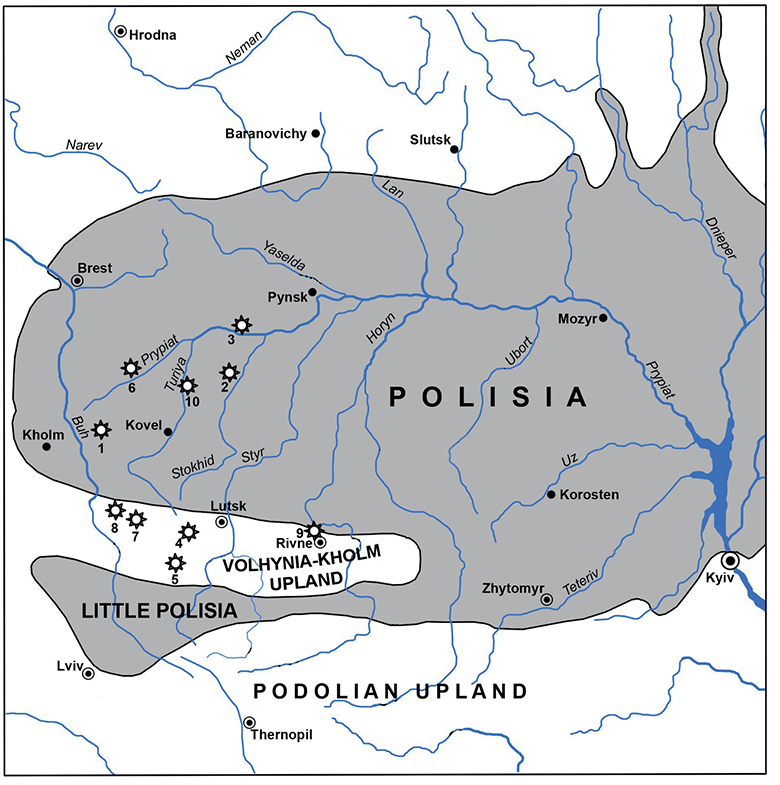
Fig. 1. Map of the hillforts of the “motte” tradition on the territory of Volyn: 1 – Lyuboml; 2 – Kamin-Kashyrsky; 3 – Vetly; 4 – Korshiv; 5 – Gorodyshche; 6 – Ratno; 7 – Falemychi; 8 – Pyatydni; 9 – Khotyn; 10 – Kachyn. Compiled by S. Panishko.
1 pav. Moto tipo piliakalnių paplitimo Voluinės regione žemėlapis: 1 – Lyuboml; 2 – Kamin-Kashyrsky; 3 – Vetly; 4 – Korshiv; 5 – Gorodyshche; 6 – Ratno; 7 – Falemychi; 8 – Pyatydni; 9 – Khotyn; 10 – Kachyn. Žemėlapį sudarė S. Panishko
A well-morphologically distinguished monument and the largest in size is the “Fossia” hillfort in Lyuboml Volyn region (Rappoport, 1967, p. 50; Panishko, 2004). It is a round hill with a top platform 60 m in diameter (Figure 2).
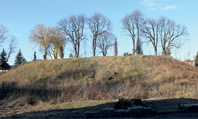
Fig. 2. Lyuboml hillfort's – “Fosia.” Southern view. Photo by S. Panishko.
2 pav. Lyuboml piliakalnio gynybinis griovys. Vaizdas iš pietų. S. Panishko nuotrauka
A downhole on the site of the hillfort allowed to assert its bulky character and to establish a stratigraphy of filling, which had the following form: 1) Dark soil with clay impurities (1.3 m); 2) White clay (0.4 m); 3) Dark soil mixed with clay (0.9 m); 4) White, well-tramped clay (1 m); 5) A layer of building rubbish of the modern time (0,8 m), it should be borne in mind that the downhole was laid on the site at 1.3 m below the current level of the settlement site. Consequently, the received stratigraphic column reflected layers with a bedding of 5.7 m. Filling was carried out at the milestone of the 13th–14th centuries.
At the time of the first investigation in 1961, the hillfort in the Kamin-Kashyrskyi Volyn region (Rappoport, 1967, p. 101–102; Panishko, 2006) was a mound of 6 meters height with steep slopes. Its site was as big as 75 × 100 m.
The results of archaeological research testify that the settlement on the site of the fortification appeared not earlier than in the 12th century, but the first fortifications in the form of a sharf there were constructed in the post-Mongolian period.
The age determination of a powerful filling (Fig. 3), which gave the form of a “motte,” can be done by analyzing the ceramic material in its lower layers. There were many edges of the 14th century, which in any case were not found in the embankment of an earlier shaft. The same was the situation in the center of the settlement. There are well-dated wooden constructions of the 12th–13th centuries overlapped with a layer of the 14th century. Consequently, the construction of hillforts in Kamin-Kashyrskyi can be attributed to the 14th century (Panishko, 2006).
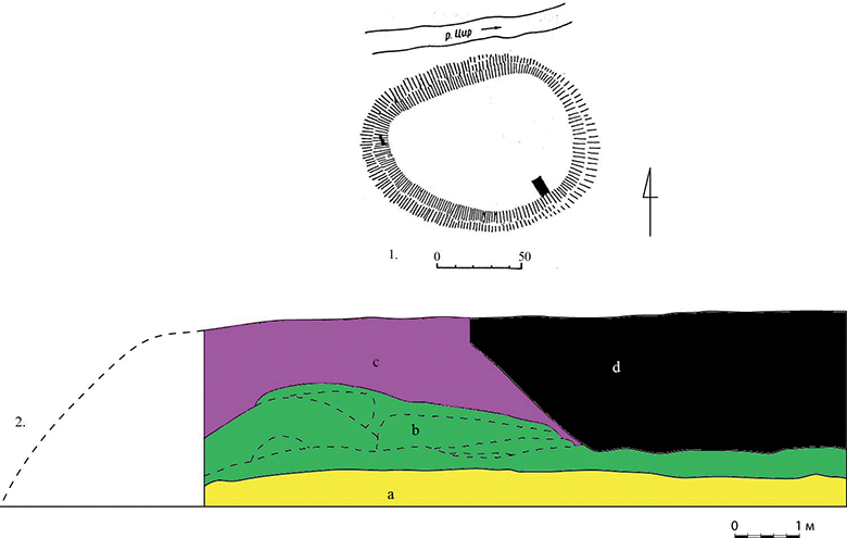
Fig 3. Kamin-Kashyrsky hillfort: 1 – plan; 2 – section of the embankment (a – continent, b – Old Russian shaft, c – leveling enbankment, d – late medieval pit). Figure by S. Panishko.
3 pav. Kamin-Kashyrsky piliakalnis: 1 – planas, 2 – pylimo pjūvis (a – pirminis paviršius, b – Senosios Rusios struktūros, c – pylimo paviršius, d – vėlyvųjų viduramžių perkasimas). Autorius S. Panishko
The hillfort in the Vetly Lyubeshiv District of the Volyn region (Rappoport, 1967, p. 45; Panishko, 2008) is an almost round embankment of 2 m height above the level of the floodplain with a horizontal site with a diameter of 45 m. No traces of the shaft and the moat on the modern surface of the monument around the embankment can be observed. To study the design of the embankment from the center of the site to its northwestern edge, a trench in size of 1 × 20 m was excavated. The trench showed that directly on the mainland there was a layer of ancient buried glay soil with a capacity of 0.2 m without any traces of human cultural activity. It traced a number of fillings, which can be grouped in three areas. From the outer edge of the hillfort, there was a shaft-shaped embankment from a homogeneous yellow clay with a width of 7 m and a height of 0.9 m. A circular structure of 4.5 m wide was adjacent to it, which was placed on a pipeline of 0.5 m capacity. And finally, the inner space of the settlement site of the hillfort with a diameter of about 15 m was also spilled. The ring building was dated by the ceramics of the middle and the second half of the 13th century.
Apparently, after the construction of the first defensive fortifications at the Vetly hillfort, the population lived there for not too long and left that place gradually, as evidenced by the poverty of the material. At the same time, we can talk about preserving of the defensive role of this monument even at the time of when the settlement had stopped functioning there. It was then that on the place of the previous fortifications a leveling ditch with a capacity of up to 0.5 m was carried out, which gave the mound shape to the fort.
To the second type of fortifications of the tradition “motte” in Volhynia belong the embankments of medium size, which could accommodate several buildings (a yard). Fortifications of such ancient hillforts were investigated nearby Lutsk in Korshiv and Gorodyshche I. Based on the evidence of the written sources, these were courtyards (castles) of wealthy feudal lords. Such settlements are classified by L. Kaiser (Marcinsak-Kaizer, 2011, p. 34) and belong to the “Folwark” type.
According to the external morphological features, the Korshiv settlement (Panishko, 2009) consists of two parts – the central one, the “motte,” which is now visually perceived as Detinets with an area of 0.9 hectares and a round-about city with an area of more than 5 hectares. Attention is drawn to the difference in the form of fortifications of these two parts. If the roundabout city is surrounded by a classic shaft that in some areas is supplemented by a moat from inside, then the “Detinets” has the form of a classic mound hill. This is a rounded mound with a horizontal top site in size of 50 × 65 m.
The mound embankment was cut by a trench in size of 1 × 13 m, which was laid in its southwestern part (Fig. 4). It was established that the first fortifications of the Detinets in Korshiv hillfort in the form of a shaft embankment with a stretched inner hollow were constructed in the 11th century. The second stage of reinforcement of the investigated section of the Detinets was a large-scale subsidence. As a result of this, the site of the settlement acquired a characteristic of mound shape. The bulk of the escarpage obtained during the filling is now reaching a height of 2.5 m. The filling contains materials from the 12th–13th centuries, indicating the lower chronological limit of its carrying. A proof of the settlement’s function, and more precisely its role as a military object, is a finding of a crossbow bolt in its territory dating back to the late period.
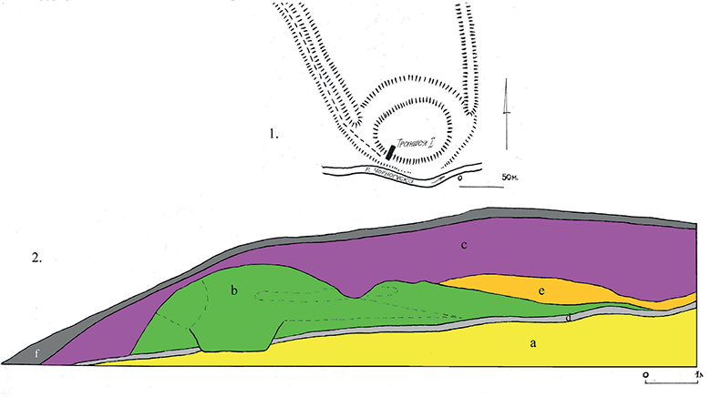
Fig. 4. Korshiv hillfort: 1 – plan; 2 – section of the embankment (a – continent, b – Old Russian shaft, c – leveling enbankment, d – black soil, e – clay, f – turf layer). Figure by S. Panishko.
4 pav. Korshiv piliakalnis: 1 – planas, 2 – pylimo pjūvis (a – pirminis paviršius, b – Senosios Rusios struktūros, c – pylimo paviršius, d – juoda žemė, e – molis, f – durpių sluoksnis). Autorius S. Panishko
The hillfort in Gorodyshche I is a round hill (Fig. 5) with a horizontal top site in size of 65 × 60 m and has a height of 5 m above the floodplain level, partly destroyed by a quarry. With an external outline of the nearby settlement the shaft reinforcement traces, but their character was not been established yet. A trench in size of 15 × 1 m stretching from the center to the western border of the fortification was laid on the station of the settlement. The depth of layers and fillings, investigated in it to the level of the mainland, reached 2 m in height. Despite the small volume of work, it was possible to find out a number of features of the internal structure of the mound.
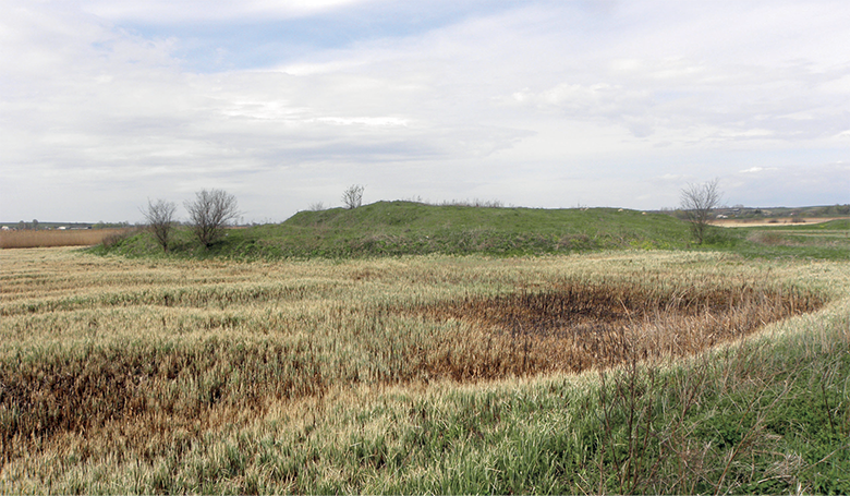
Fig. 5. Gorodyshche 1 Hillfort. Lutsk District. View from the northeast. Photo by S. Panishko
5 pav. Gorodyshche 1 piliakalnis, Lucko rajonas. Vaizdas iš šiaurės rytų. S. Panishko nuotrauka
Its fortifications were constructed in two stages. Early fortifications were the embankment of 3 m width and 0.5 m height. From the outer side of the embankment, a ditch was stirred. On the territory of the mound, a cultural layer lying on the mainland contained the findings of the 10th–13th centuries. Not earlier than in the 16th century, there was a second stage of hillforts. There was a large one (up to 1 m) dipping with light continental clay all over the site, due to which it acquired the current mound shape (Bajuk, 2013).
The third group includes fortifications with a well-morphologically distinguished “motte” of a small area. Only one tower could be placed on the upper sites of such hills. Such monuments are known in Ratno, Falemychi, Pyatydni. The last two are located near the great late-medieval administrative center of Volyn – the city of Volodymyr. Excavations on those objects were not carried out.
In 1960, the hillfort in the Ratno Volyn region was investigated by P. O. Rappoport (Rappoport, 1967, Fig. 23; Panishko, 2012). The researcher noted that that mound is located on an island up to 2–3 m in the territory of marshland. It had a form of a rounded height of 60 m in diameter, the entrance to which is traced from the west side. At the eastern edge of the ascension at the time of the investigation made by P. O. Rappoport, an earthen hill about 2 m height with a top platform with a diameter of 12 m, is preserved (Fig. 6). According to the researcher, that embankment was the foundation of the tower, built in the 14th century. The earliest ceramic material from the Ratno hilllfort was reffered by P. O. Rappoport to the 12th century.
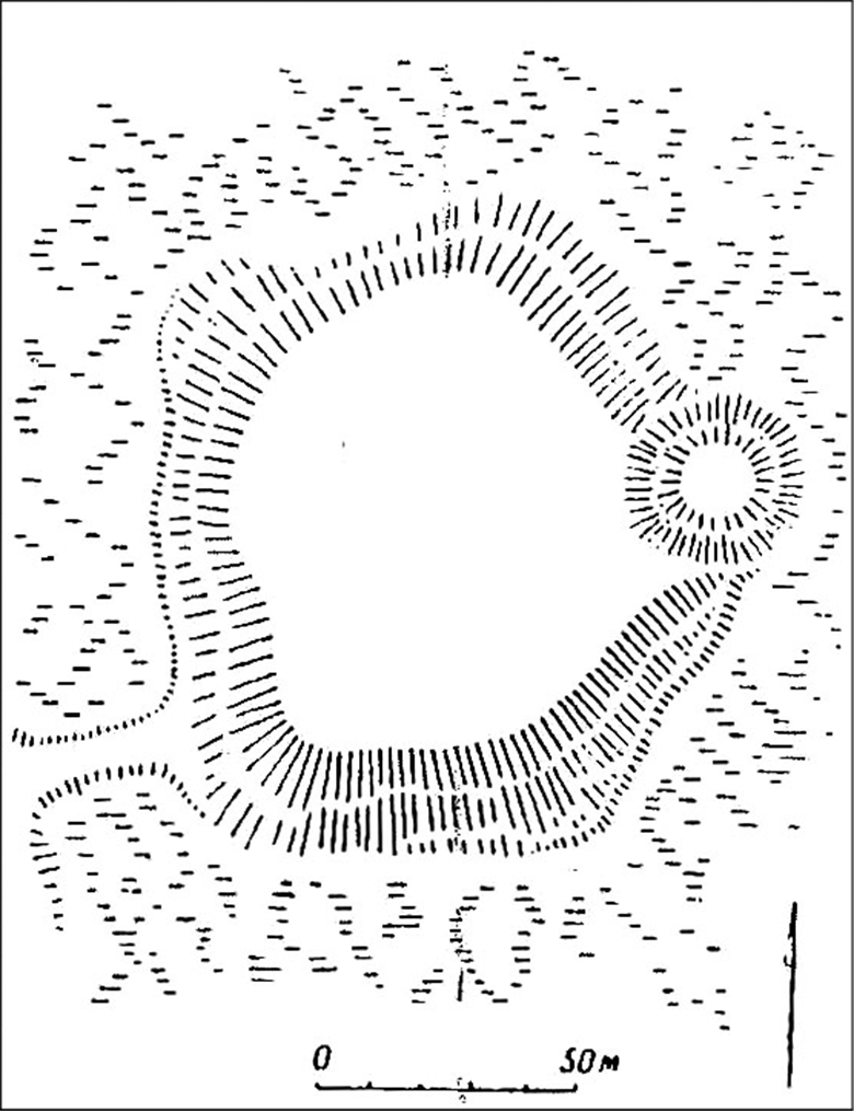
Fig. 6. Ratno Hillfort. Plan. (according to Rappoport, 1967, Fig. 23).
6 pav. Ratno piliakalnis. Planas (pagal Rappoport, 1967, pav. 23)
During the time passed after the investigation of the monument by P. O. Rappoport, the settlement has undergone significant destruction. Due to the plowing of its surface, the cultural layer was partially damaged in many parts of the settlement, and the contours of the bulk hill in its eastern part were practically obliterated. At the present time, it can be stated that the plan of the Ratno settlement, taken by P. O. Rappoport, reflected the modern external view of the monument and fixed its morphological features the most accurately.
With great probability, it is possible to talk about the design of the modern external view of the Ratno settlement (with a hill), as it occurred during the period of its allocation as a private administrative center – a feudal castle. That could have happened in three periods: after 1366, when Ratno was perhaps the center of Volyn possessions of Olexander Koriyatovych; after 1377, when the city became the center of the autonomous Ratne principality of Theodore Olgerdovych; and after 1443, when part of the former secular principality with Ratno belonged to Sangush Lyubartovych, already as a patrimonial possession.
However, in 1366, Ratne was a state city, the center of a separate volost-sotnia (Panishko, 1992, p. 28). Apparently, it was at that time when the embankment of the settlement was constructed. Subsequently, when Ratne acquired the role of a feudal castle, a hill was buried under the separate tower on the eastern edge of the settlement.
The hillfort in Falemychi in the “Selysko” area was investigatd by O. Tsynkalovsky and S. Tersky (Tersky, 2010, 109, p. 58–59). The monument consists of two parts. An open settlement without visible traces of fortifications in size of 130 × 50 m (1.5 ha) is located on the highest part of the remaining ascension in the floodplain of the left bank of the Luga River. It is situated on the western part isolated circular mound, with a diameter of 40 m and a height of 8 m. The geographical and morphological features of the surrounding space indicate that this is not a natural formation but an artificial mound. The top of the embankment is rounded, so it is visually perceived as a large mound. On the territory of the open settlement, ceramics were found dating back to the 12th–18th centuries.
Falemychi is mentioned in the chronicle in 1157 as Khvalymychi. S. Tersky connects the origin of this title with the name of the first owner, Khval, and suggests the existence of a boyar manor, which is localized on the capes of the eastern and northern parts of the modern village. In the territory of the hillfort, in his opinion, in the 12th–18th centuries, there was a town with a castle.
The monument has not been excavated, but the external morphological features of the isolated embankment, its proximity to the open settlement and the dating of the settlement complex make it possible to refer it to the fortresses of the “motte and bailey” type, or small mound settlements – the remnants of the knight yards of the fourteenth and fifteenth centuries (Figure 7). Such an interpretation does not exclude the possibility of existence on this place of the ancient fortified settlement in the 12th–13th centuries on the one hand, and does not contradict the redevelopment of this knight’s court in a small wooden-earthen castle, known from written sources, during the 16th–17th centuries.
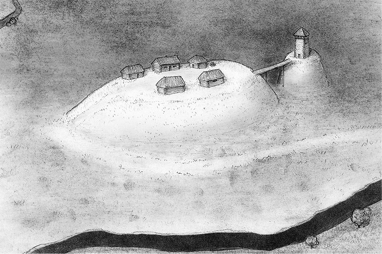
Fig. 7. Falemychi Hillfort. Reconstruction made by A. Panikarsky.
7 pav. Falemychi piliakalnis. Rekonstrukcijos autorius A. Panikarsky
Another monument, which, with a high degree of probability, can be reffered to small mound ones, is the hillfort in “Osiyanska Hora” in the village Pyatydni of the Volodymyr-Volynskyi District. The hill was investigated by O. Tsynkalovsky and S. Tersky (Tersky, 2010, p. 115, Figure 62). S. Tersky points to the escarpment of the slopes of the settlement and considers it one of the original centers of the western part of the urban agglomeration of ancient Volodymyr.
The hill is situated in an elongated end of the floodplain terrace of the right bank of the Luga River, which rises above the floodplain level by 5–7 m. The modern look of the remnant has distinct traces of anthropogenic replanning. In its eastern part it is possible to see a sub-rectangular platform in size of 45 × 20 m. The average part of the summit at a depth of about 20 m is severely narrowed and somewhat lowered, but on the western edge of it, it moves into a clearly expressed, rounded elevation with an upper platform with a diameter of about 8 m. The level of this small area exceeds the level of the eastern part of the remnant by 2 m. It should be noted that the exact dating of this monument is still absent.
The Khotyn village of Rivne District, Rivne Region has strongly marked external morphological features of the “motte and bailey” fortifications. The first information about the hillfort in Khotyn was filed by V. Antono-vych. He wrote that there was an oval mound in the village in size of 90 × 60 m. In ascension on which the fortress was located, there was an underground passage of 60 m in length and a height of 2 m with a blocked entrance (Antonovych, 1900, p. 43). This information was repeated by O. Cynkalovsky (Cynkałowski, 1961, p. 176, 206).
Describing the hillfort, the researchers did not identify in its complex a high earthen hill, about 20 m in diameter, situated on the cape, which is situated on the main site of the hillfort. According to the external morphological features, this hill can be entirely referred to the “motte” of the medieval castle. In this case, the “bailey” was the main site of the settlement.
Among the bulky fortifications of the “motte” tradition in the Volyn region, the main position has an artificial embankment in the middle of the lake (crannog) in the village Kachyn Kamin-Kashyrsky District, Volyn Region (Panishko, 2017). It is known from written sources that there was a Bukovetsky castle built in the 16th century. According to a local legend, the island was artificially piled in the middle of Kachynsky Lake, with a palace. The passage to the island passed on a bridge laid on piles. The lake in its original natural state has an area of 42 hectares; however, as a result of drainage works in the middle of the 20th century, the water level had decreased, and the area of the lake has reduced. As a result, the island’s fortification united with the coast by the isthmus, transforming into a peninsula (Fig. 8).

Fig. 8. Kachyn Hillfort. Location.
8 pav. Kachyn piliakalnis
Nowadays the fortification is located in the tract “Kemp” on the promontory of the northern shore of the lake. It represents an oval shape in size of 45 × 70 m. The eastern part of the elevation has a horizontal surface and well-defined steep edges up to 3.0 m high, which break from the east and the south to the lake and from the north to the clearly pronounced downfall, which was still in the 1950s occupied by the waters of the lake.
Although the morphological features of ascension indicated its man-made origin, its confirmation of the breeding nature of the “Kemp” embankment was made by its shuffling. A test pit of 2 × 2 m in size was laid in the central part of the ascension. The obtained layers’ stratigraphy was as follows: 0.0–0.85 – a humus crop layer, below which the mixed layer was located, which consisted of sand and clay, and the inclusion of clay were represented not by horizontal lenses but by compact clusters. At a depth of 2.65 m from the level of the hillfort site there was a level of groundwater.
Below the level of groundwater, the excavation of soil from the test pit was difficult, since the sandy walls of the test pit in the water were not kept. Still, at a depth of 2.8 m, it was possible to fix a layer of sand containing well-preserved traces of organic matter in the form of algae residues. Consequently, the hill on which the fortification was located fell on a very low place, obviously, in the shallow water of the lake. The maturation can be performed on the basis of the analysis of the finds from the shurf, the earliest of which belonged to the 16th century.
Conclusions
The available sources allow us to distinguish three types of fortifications of the “motte” tradition in Volyn. The hillforts of a relatively large area, investigated in Luboml, Kamin-Kashyrsky and Vetly belong to the first type. They are the remnants of small feudal cities, centers of volosts-sotnias, mentioned in the middle of the 14th century. Such monuments are located in the northern part of Polissya of Volyn land.
The second and third types are represented, obviously, by fortifications of a private nature. The second type includes relatively large objects (Korshiv fortress, Gorodysche 1), which could be the courts of large feudal lords.
To third type belong the small hills, where only one wooden tower can be located (Ratno, Falemichi, Pyatydni). These were the classic “motte and bailey” fortifications, where small feudal lords – knights – had lived. Such private-owned monuments are concentrated near major administrative centers, but they also occur in the more remote regions of Volyn.
In most cases, the construction of the bulked “motte” dates back to the 14th–16th centuries – that is, the time when Volyn entered the Grand Duchy of Lithuania. That period was the time of the active formation of the small landowner’s class. Already the circumstances of the entry into the property of the Grand Duchy affected the relevance of distribution of the state lands for Vladimir Mstyslav Danylovych. Lyubart and Svidrigailo were the most generous in that respect.
Literature
Cynkałowski A. 1961. Materiały do pradziejów Wołynia i Polesia Wołyńskiego. Warszawa, PTA.
Kaminska J. 1966. Grodziska stożkowate śladem posiadlości rycerskich XIII–XIV wieku. Prace і materialy museum archeologicznego і etnograficznego w Łodzi, 13. Łodz, s. 43–78.
Marcinsak-Kaizer A. 2011. Sredniowieczny dwor rycerski w Polsce. Wizerunek archeologiczny. Lodz: Wydawnictwo Uniwersytetu Lodzkiego.
Антонович В.Б. 1900. Археологическая карта Волынской губернии. Москва: Типографія Г. Лисснера и А. Гешеля.
Баюк В. 2013. Археологічний комплекс давньоруського часу біля с. Городища-1 Луцького району. Літопис Волині, 12, с. 5–12.
Конецкий В.Я., Трояновский С.В. 2013. «Большая сопка» Передольского погоста: варианты интерпретации. Новгород и Новгородская земля: история и археология. Материалы научной конференции, посвященной 80-летию со дня рождения М.Х. Алешковского, 27. Великий Новгород: Новгород. гос. объедин. музей-заповедник, с. 233–250.
Панишко С.Д. 1992. Структура Волинської землі середини ХІV ст. Родовід, 3. Київ, с. 26–30.
Панишко С.Д. 1992. Дослідження оборонних споруд на давньоруських городищах Волині. Археологічні дослідження проведені на території України протягом 80-х років державними органами охорони пам’яток та музеями республіки. Київ: Національний музей Історії України, с. 111–119.
Панишко С.Д. 2004. Дослідження ранньосередньовічного Любомля. Замосцько-волинські музейні зошити, ІІ. Zamosc: Muzeum Zamjskie w Zamosciu, с. 255–262.
Панишко С.Д. 2006. Археологічні дослідження давньоруського Каменя. Минуле і сучасне Волині та Полісся, 20. Луцьк: Пульс, с. 14–19.
Панишко С.Д. 2008. Про результати археологічних досліджень городища в селі Ветли Любешівського району. Минуле і сучасне Волині та Полісся, 28. Луцьк: Пульс, с. 313–316.
Панишко С.Д. 2009. Коршівське городище. Науковий вісник Волинського національного університету імені Лесі Українки, 13. Луцьк, с. 67–73.
Панишко С.Д. 2011. Стіжкові городища Волині. Матеріали і дослідження з археології Прикарпаття і Волині, 15. Львів: Ін-т українознавства ім. І. Крип’якевича НАН України, с. 329–337.
Панишко С.Д. 2012. Укріплення типу «motte and bailey» у смт. Ратне. Минуле і сучасне Волині та Полісся, 42. Луцьк: Волинські старожитності, с. 24–27.
Панишко С.Д. 2012. Городища «motte and bailey» як перші лицарські двори Волині. Матеріали і дослідження з археології Прикарпаття і Волині, 16. Львів: Інститут українознавства ім. І. Крип’якевича НАН України, с. 205–215.
Панишко С.Д. 2016 Матеріали до класифікації пізньосередньовічних укріплень традиції «motte» на Волині. Археологія і давня історія України, 4 (21). Київ: Наукова думка, с. 61–70.
Панишко С.Д. 2017. Пізньосередньовічний кранног в с. Качин на Волинському Поліссі. Дубенський науковий вісник, 1. Рівне: Дятлик М., с. 50–52.
Раппопорт П.А. 1967. Военное зодчество западнорусских земель X–XIV вв. Ленинград: Наука.
Терський С.В. 2010. Княже місто Володимир. Львів: Видавництво Національного університету «Львівська політехніка».
Piliakalniai: moto tipo įtvirtinimų tradicija Voluinės regione lietuviškajame periode
Sergey Panishko
Santrauka
Europos rezidencinės kultūros elementai, konkrečiau – moto tipo įtvirtinimai, Voluinės regione datuojami nuo XIV a. Jiems būdinga kalva su stačiais šlaitais ir aikštele viršūnėje (motas). Kartais jie yra didesnių įtvirtinimų, datuojamų vėlyvaisiais viduramžiais, sudedamoji dalis. Nors šio tipo įtvirtinimai aptariamame regione buvo identifikuoti palyginti neseniai, juos galima sugrupuoti į tris grupes. Pirmoji grupė – Polesės piliakalniai (Lyuboml, Kamin-Kashyrsky, Vetly), kurie buvo tam tikrų miestų dalys. Lyuboml senovės gyvenvietė buvo įsikūrusi piliakalnyje, kurio šlaitų aukštis – 6 m, o aikštelės skersmuo – 60 m. Kamin-Kashyrsky piliakalnio šlaitai yra 6 m aukščio, aikštelė – 75 × 100 m dydžio. Mažiausias šio tipo piliakalnis yra Vetly, jo šlaitų aukštis – 2 m, o aikštelės skersmuo – 45 m. Antra piliakalnių grupė yra moto tipo – vidutinio dydžio piliakalniai. Rašytinių šaltinių duomenimis, tai turtingų feodalų rezidencinės pilys. Korshiv motas yra 2,5 m aukščio, ovalios aikštelės dydis – 50 × 65 m. Gorodyshche kaime esanti kalva – beveik apskritimo formos, 5 m aukščio, jos aikštelė – 60 m skersmens. Trečia grupė – tai gerai morfologiškai identifikuojamas motas, pasižymintis kompaktiška teritorija. Tokių įtvirtinimų aikštelėse galėjo būti pastatytas tik vienas bokštas. Šie įtvirtinimai greičiausiai priklausė kunigaikščiams. Tai – Ratno, Falemychi ir Pyatydni paminklai. Pastarieji du yra įsikūrę greta Volodymyr miesto, kuris vėlyvaisiais viduramžiais buvo stambus Voluinės administracinis centras. Geriausiai išlikęs šios grupės moto tipo objektas yra Ratno. Jo aukštis siekia 2 m, aikštelės skersmuo – 12 m. Tokio tipo įtvirtinimai yra išlikę ir Khotyn kaime. Išskirtinis tipas – tai laikantis moto tradicijos įrengtas piliakalnis, kurio aikštelės dydis yra 45 × 70 m, o šlaitų aukštis – 3 m. Jis yra ežero, esančio Kachyn kaime Voluinės regione, viduryje (vadinamasis „crannog“).