Archaeologia Lituana ISSN 1392-6748 eISSN 2538-8738
2024, vol. 25, pp. 52–65 DOI: https://doi.org/10.15388/ArchLit.2024.25.3
Hubert Binnebesel
Institute of Archaeology, Nicolaus Copernicus University, 44/48 Szosa Bydgoska Street, 87–100 Toruń, Poland
hbinnebesel@doktorant.umk.pl
ORCID: https://orcid.org/0000-0003-3467-687X
Magdalena Sudoł-Procyk
Institute of Archaeology, Nicolaus Copernicus University, 44/48 Szosa Bydgoska Street, 87–100 Toruń, Poland
sudol@umk.pl
ORCID: https://orcid.org/0000-0003-4099-5893
Abstract. The prehistoric chocolate flint mine in the Udorka Valley (site 24 in Poręba Dzierżna, Lesser Poland Voivodeship, southern Poland) has been under excavation since 2018. It is the first mine of this raw material discovered outside the Świętokrzyskie Mountains. The currently available dating indicates that the mine was used in the Mesolithic and Neolithic periods.
Spatial analysis of artifacts from the fill of the mine shaft allowed for the reconstruction of individual phases of its formation. It also questioned the issue of homogeneity of the assemblage of artifacts from this mining facility and from the overlying layers. Although they are of the workshop type, their simultaneity should be doubted. In order to establish the chronological and cultural framework of flint production in the mining field, it seems necessary to determine the original location of the workshop, which was destroyed and washed out as a result of some kind of runoff. This flow created the sediment that now lies above the shafts, and which is extremely rich in flint artifacts.
Keywords: prehistoric mining, flint workshops, stone age, geoarchaeology, GIS Spatial Analysis.
Anotacija. Priešistorinėje šokoladinio titnago kasykloje Udorkos slėnyje (24 vietovė, Poręba Dzierżna, Mažosios Lenkijos vaivadija, Pietų Lenkija) kasinėjama nuo 2018 m. Tai pirmoji šios žaliavos kasykla, aptikta už Świętokrzyskie kalnų ribų. Remiantis šiuo metu turimomis datomis, kasykla buvo naudojama mezolito ir neolito laikotarpiais.
Šachtos ùžpildo artefaktų erdvinė analizė leido rekonstruoti atskirus šachtos formavimosi etapus. Analizė taip pat iškėlė šio kasyklos objekto ir jį sudarančių sluoksnių bei artefaktų rinkinio homogeniškumo klausimą. Nors radiniai būdingi titnago apdirbimo vietos radiniams, tačiau jų vienalaikiškumu taip pat derėtų abejoti. Norint nustatyti chronologines ir kultūrines šios titnago kasimo ir apdirbimo vietos ribas, atrodo, būtina nustatyti pirminę dirbtuvių vietą, kuri buvo sunaikinta ir išplauta vandens srovės. Dėl šio vandens judėjimo susidarė nuosėdos, kurios dabar yra virš šachtų ir kuriose itin gausu titnago dirbinių.
Reikšminiai žodžiai: priešistorinė kasyba, titnago dirbtuvės, akmens amžius, geoarcheologija, erdvinė analizė.
__________
The study was supported by the National Science Centre, Poland (grant number 2018/30/E/HS3/00567).
Tyrimus parėmė Nacionalinis mokslo centras, Lenkija (sutartis numeris 2018/30/E/HS3/00567).
Received: 14/11/2024. Accepted: 05/12/2024
Copyright © 2024 Hubert Binnebesel, Magdalena Sudoł-Procyk. Published by Vilnius University Press. This is an Open Access article distributed under the terms of the Creative Commons Attribution License, which permits unrestricted use, distribution, and reproduction in any medium, provided the original author and source are credited.
Site 24 in Poręba Dzierżna (Lesser Poland Voivodeship, Wolbrom commune, Poland) is the first prehistoric chocolate flint mine discovered outside the area of the Świętokrzyskie Mountains. This raw material was highly valued by prehistoric communities from the Paleolithic to the Neolithic and the Bronze Age, because products made of it are found throughout today’s Poland and many Central European countries, including Lithuania, Belarus, Ukraine, Slovakia, the Czech Republic and Austria (Sulgostowska, 2005). For this reason, a good understanding of the nature and chronology of flint production in the mining field in the Udorka Valley (site 24 in Poręba Dzierżna) is extremely important for further research on the distribution of raw materials in prehistoric Central Europe. The results of previous studies, and, in particular, the spatial analysis of the finds, indicate that, in order to achieve this goal, it will be necessary to locate flint workshops associated with the mine. These workshops were washed away, and the artifacts from them were moved down the slope as a result of some kind of mass movement. This term means the movement of rock masses under the influence of gravity. Recognizing its nature requires further research, but it should be assumed that it was a type of flow, most likely a mudflow (according to the definition by Mizerski, 2022, 199, 208–210). For this reason, the currently found flint products cannot be considered homogeneous. In order to determine the original location of the flint workshops, it is planned to use spatial analysis of flint artifacts. This will also allow to determine the probable causes of the destruction of the workshops and the redeposition of flint products.
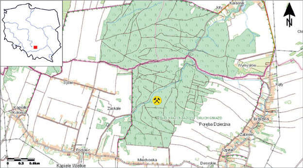
The mining field is located in Southern Poland, in the area of the village of Poręba Dzierżna (site 24) in the Lesser Poland Voivodeship. This is the area of the Kraków-Częstochowa Upland, also known as the Polish Jura (Fig. 1). The site occupies an area of at least 1 hectare on the eastern slope of the Udorka Valley. The valley slopes are relatively steep, and the edges in its lowest part are strongly eroded by the periodically flowing river (Udorka).
Fig. 1. Location of site 24 in Poręba Dzierżna in the context of the region and Poland.
1 pav. 24 vietovės Poręba Dzierżna regione ir Lenkijos kontekste vieta.
Natural outcrops of chocolate flint in the Udorka Valley were located in 2013 by a team led by M. Sudoł. This was an extremely important discovery, because, until now, outcrops of this raw material were associated exclusively with the area of the Świętokrzyskie Mountains (Ginter, Kozłowski, 1975, 22–27). In the immediate vicinity of the flint outcrop, numerous niches were found, the range of which was illustrated by LIDAR (Sudoł-Procyk et al., 2018). Their anthropogenic nature was confirmed by research conducted since 2018 as part of the National Science Centre grant No. 2018/30/E/HS3/00567 Chocolate Flint in the Kraków-Częstochowa Upland. Extraction, Use and Distribution under the direction of M. Sudoł-Procyk. In the course of the research, a series of excavations was established located in the lower part of the site. In Trenches I, II and III, relics of mining facilities were documented (Fig. 2). In this way, it was confirmed that the Udorka Valley contains the remains of a prehistoric chocolate flint mine, currently the only one known outside the Świętokrzyskie Mountains. C14 and OSL dating obtained for samples from shaft fills indicate its multiphase nature, reaching back at least from the early Mesolithic to the Neolithic periods (Sudoł-Procyk et al., 2021). Work is still ongoing.
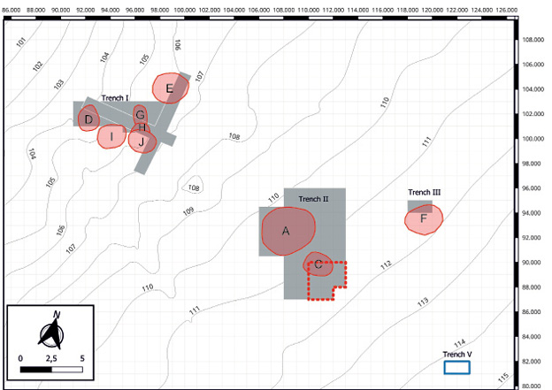
Fig. 2. Location of research trenches at site 24 in Poręba Dzierżna. Legend: gray color – trench boundaries; blue rectangle – geological trench from 2021; red circles (A – J) – outlines of mining facilities; red dashed line – area covered by the research described below in the 2023 season.
2 pav. Tyrimų perkasų plotai 24-oje Poręba Dzierżna vietovėje. Legenda: pilka spalva – perkasų ribos; mėlynas stačiakampis – 2021 m. geologinė tranšėja; raudoni apskritimai (A–J) – kasybos objektų kontūrai; raudona punktyrinė linija – teritorija, kurioje 2023 m. sezoną atlikti tyrimai, aprašyti šiame straipsnyje toliau.
The site is located on a steep Eastern slope of the Udorka Valley. The valley area is covered with dense forest, which made it difficult to locate it and clearly recognize its anthropogenic nature in the first stage of research. The site’s area was estimated as at least 1 hectare based on LIDAR. The mining relief of the terrain has been preserved in an exceptionally good condition to this day. The outlines of shafts and spoil heaps are clearly visible. Based on their external morphology, as revealed by LIDAR, the site was divided into 4 zones (Fig. 3). Closest to the bottom of the valley, there are numerous small niches, opening towards the river. This area is partially eroded by the activity of flowing water. In zone 2, deep depressions with a diameter of up to 3 meters are visible. Further on, there is zone 3, the most extensive of all the separated zones. It occupies a relatively flat area. The outlines of mining facilities are the least visible. In zone 4, the largest niches can be observed, reaching up to 25 meters in diameter. They have not yet been the subject of research; therefore, their chronology and purpose still remain unknown (Sudoł-Procyk et al., 2021, p. 114–116).
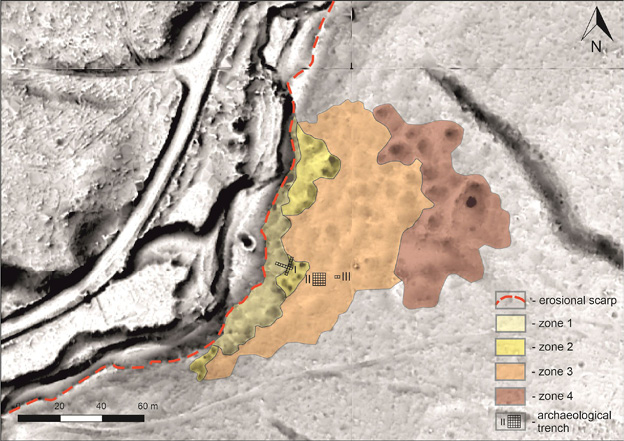
Fig. 3. Morphology of the site with marked zones of the mining field (after Sudoł-Procyk et al., 2021).
3 pav. Vietovės morfologija su pažymėtomis titnago kasyklos zonomis (pagal Sudoł-Procyk et al., 2021).
During the research, a similar stratigraphic situation was observed in all identified trenches (Fig. 4). Under a relatively shallow layer of humus (layers 10 and 9), there is a layer of redeposited loess (layer 8). This is a layer extremely rich in archaeological materials of the workshop type. In Trench II, about half of all found products come from layer 8. The dominant types of artifacts are flakes (about 42%) and industrial waste (about 44%) (data based on research from 2019–2022). Blades and their fragments have also been found (Fig. 5). The cores are not very numerous, but their characteristics indicate that they come from the initial phase of exploitation (Fig. 6). Pre-core forms and natural concretions with single impacts are more numerous than cores. Tools occur very rarely and are of the mining type (Fig. 7) (Binnebesel, 2022a, 36–40). This characteristic corresponds to a mining workshop according to J. Lech’s typology (Lech, 1981, 102). The redeposition of loess layer 8 is confirmed by geological analysis carried out by M. Krajcarz from the Institute of Geological Sciences of the Polish Academy of Sciences in Warsaw, as well as OSL dating indicating the Holocene period (Sudoł-Procyk et al., 2021). This layer has a varied depth, from 20 cm to even a meter. Its lower part strongly stands out from the light gray loess occurring below (layer 7). Layer 7 is most likely located in situ. Flint products are also found in it, but not as numerous as in layer 8. This layer seems to be heavily damaged by some form of mudflow. Only its lower part has survived to this day, forming numerous wedges measuring from several centimeters to even two meters. There are places where this layer is completely absent, and the flow layer (layer 8) is located directly above layer 6. The upper part of layer 7 was most likely washed away as a result of the aforementioned, as yet unidentified mass movement (most likely a mudflow). Layer 6 is formed by reddish-orange, strongly compacted loess in situ. It is completely barren in terms of archaeological material. The thickness of this layer can reach up to several meters. Below it, we find weathered clay (layer 2) and weathered limestones, between which, there are natural flint concretions. In Trench I, under the clay and weathered limestones, it was possible to observe solid limestone, and, in it, there are two layers of chocolate flint. The mine shafts are covered with a flow layer (layer 8) and an intersect layer (layer 7) and weathered clay, reaching the clay or further to the flint layers. The connection of mining objects and layer 7 is still difficult to establish due to its wedge-shaped nature, as well as the layer lining some of the objects, which, in terms of color and structure, resemble layer 7 (e.g., layer A4 and others).
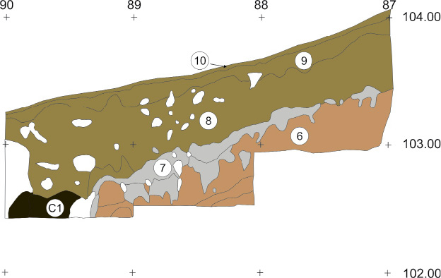
Fig. 4. General stratigraphic scheme of the site based on profile E from Trench II. 10, 9 – humiferous silt; 8 – deposits of colluvial loess; 7 – loess layer, most likely in situ; 6 – in situ layer; C1 – mining shaft fill; the white color indicates burrows and roots.
4 pav. Bendra vietovės stratigrafijos schema, sudaryta pagal II perkasos E profilį. 10, 9 – humusingas dumblas; 8 – koliuvio nuosėdos; 7 – priesmėlio sluoksnis, greičiausiai in situ; 6 – in situ sluoksnis; C1 – kasyklos šachtos užpildas; balta spalva žymi įgriuvas ir šaknis.
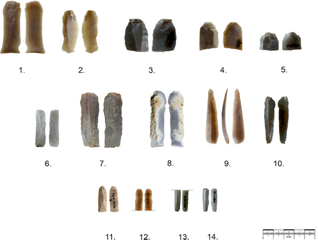
Fig. 5. Examples of blades from site 24 in Poręba Dzierżna. Photos by T. Wiśniewski and W. Ochotny.
5 pav. Penki skelčių pavyzdžiai iš 24-osios vietovės Poręba Dzierżna. T. Wiśniewski ir W. Ochotny nuotraukos.
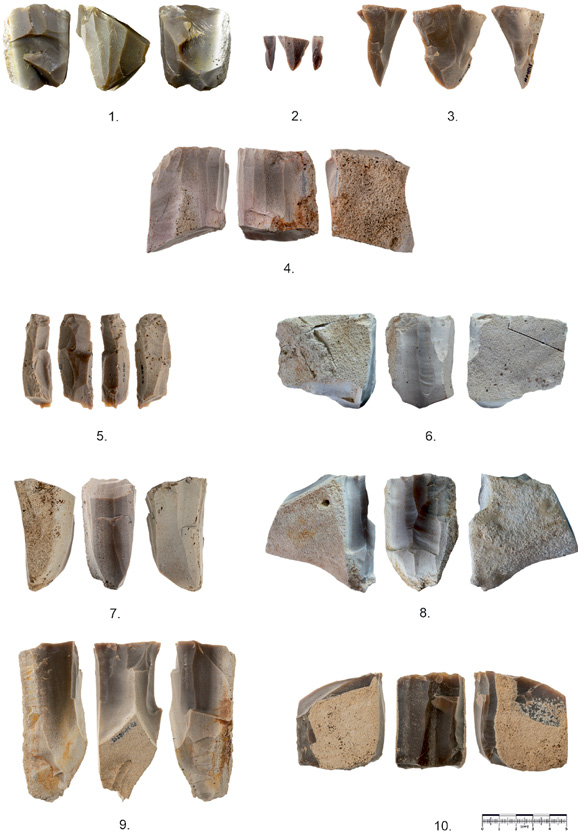
Fig. 6. Examples of cores from site 24 in Poręba Dzierżna. Photos by T. Wiśniewski and W. Ochotny.
6 pav. Skaldytinių pavyzdžiai iš 24-osios vietovės Poręba Dzierżna. T. Wiśniewski ir W. Ochotny nuotraukos.
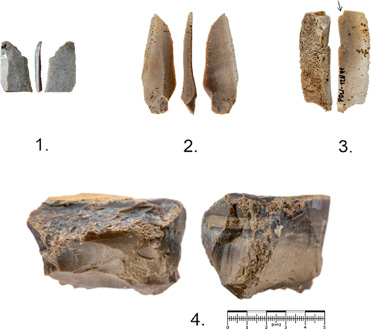
Fig. 7. Examples of tools from site 24 in Poręba Dzierżna. 1, 2 truncated piece; 3 burin; 4 hammer. Photos by T. Wiśniewski and W. Ochotny.
7 pav. Įrankių pavyzdžiai iš 24-osios vietovės Poręba Dzierżna. 1, 2 – nulaužta dalis; 3 – rėžtukas; 4 – kirvelis. T. Wiśniewski ir W. Ochotny nuotraukos.
The research work in the area of Trench II can be divided into three stages. Each of them was characterized by a slightly different methodology. At all stages, the exploration was carried out with 10 cm mechanical layers due to the complex stratigraphic situation and the expected significant number of finds. Each artifact was recorded by using a total station. In 2019, a 2x1 m test trench was opened. The obtained flint products were analyzed in terms of typological affiliation, the presence of cortex, traces of burning and patina. The finds were also weighed and measured. These results, even at such an early stage, allowed us to indicate the workshop character of the collection. The decisive factors were the large share of cortex artifacts (especially flakes) and the structure of the inventory (Binnebesel, 2022b).
The research continued in 2020–2022, gradually expanding the trench. Due to the increase in knowledge about the site and the rapidly growing number of finds, it was necessary to make some changes to the methodology. The typological list did not change significantly. The measurement of each product was abandoned and limited to weighing them. After recognizing the nature of the collection, for the purposes of spatial analysis, the presence of cortex was no longer recorded. The features still studied were the presence of patina and traces of burning. As research progressed in Trench I, and after reaching the flint deposits, an attempt was made to connect artifacts from Trench II with specific raw material deposits. A major interpretation problem was the large assemblage of white and white-gray flint finds. Initially, they were interpreted as patinated, but, in 2022, a natural chocolate flint deposit was found in weathered clay in Trench II. This raw material is characterized by a different color than that in the rock. For this reason, it will be necessary to re-examine the entire collection from 2019–2022 in terms of the presence of patina and affiliation to specific deposits.
The third stage of work in the area of Trench II has been carried out since 2023 and is still ongoing. Due to the progress of research, the goals set during the exploration of this part of the site have changed. Currently, the work focuses on the issue of homogeneity and determining the original location of the flint workshop, the relics of which are observed in the flow layer 8. The current research method is still being improved, but its main assumption is to record the arrangement of finds in order to conduct a more precise spatial analysis. It is planned to describe it in its entirety when its usefulness is definitely confirmed.
An important aspect during the research is to take into account the weight of the finds. This is of particular importance in the case of Kernel density estimation, especially in the case of such a large collection. Information on the number of flint artifacts in the case of workshops and mines seems to be less reliable than the sum of their masses. For this reason, this parameter was used to create visualizations of densities. Additionally, as work progresses in the mining field, the weight will allow for estimating the scale of extraction and production in the mine in the Udorka Valley, according to the postulates put forward by B. Balcer (2000).
When analyzing the materials obtained in the years 2019–2022, it is necessary to consider the issue of homogeneity of the entire assemblage. The first argument against its uniformity is the previously mentioned geological analysis, which characterizes layer 8 as flowing. This is the first premise to treat the finds from this sediment separately from those from the shaft fill or other layers.
Spatial analysis (Fig. 8) of products from Trench II confirms this thesis. First of all, attention should be paid to the Kernel density estimation taking into account the weight of the products (Fig. 8d). What is noteworthy is the uneven distribution of the finds, both within the shaft and in the runoff layer. In the backfill of object A, 5 horizons can be distinguished, differing in terms of the density of material occurrence. They most probably correspond to the individual stages of shaft backfilling. The lowest fraction is characterized by numerous flint materials (Fig. 8b) (516 finds, 2.3 kg). The most numerous group is that of industrial waste (91%) and fragments of natural concretions (4%). The remaining artifacts are single flakes (2%), chips (2 pieces), flakes (1%), and pre-core forms in the type of test concretions (4 pieces). The total lack of burnt and overheated finds (Fig. 8c) is noteworthy. This fraction is primarily associated with layer A14. Its location and inventory characteristics indicate that it is most likely related to the process of raw material extraction and mining activity. This sediment could have been found in the shaft while it was still in use (creating a type of internal heap), or just after extraction had ceased. A completely different situation can be found above it. Layer A12 is almost barren in finds (39 finds, 189 g). Individual products originating from it are found at its boundaries, as well as in the vicinity of burrows and roots. Very few of the artifacts can be reliably associated with this sediment (13 items). 90% of this collection is industrial waste (35 items), one of which was identified as bearing traces of overheating. In addition, 3 flakes and 1 core were found in the sediments associated with layer A12. This fraction is most probably related to the process of natural filling of the shaft with sediment from sliding walls and heaps (on which the workshops were not located). The sterility of the products, as well as the considerable thickness, can also be explained by pouring in sediments related to the digging of another, neighboring shaft.
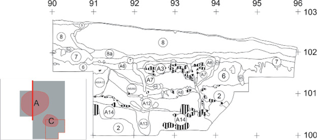
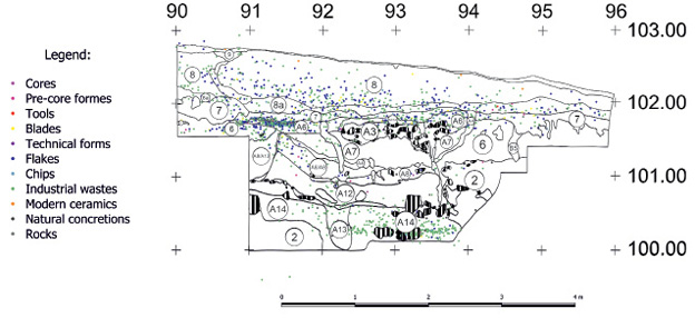
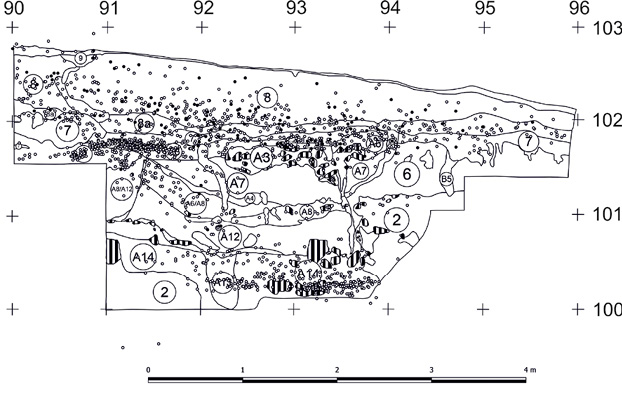
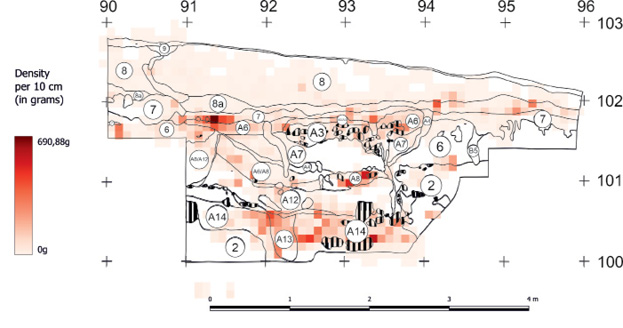
Fig 8. A. Profile W at meter 108 from Trench II. A3–A14 – anthropogenic fill layers of structure ‘A’. Areas marked with black lines – limestone rocks; B. Profile W with marked artifacts; C. Profile W with marked artifacts. Burnt or overheated finds are marked in black, while those without such traces are marked in white; D. Kernel density estimation of artifacts taking into account their weight, against the background of profile W.
8 pav. A. Profilis W ties 108 metru iš II tranšėjos. A3–A14 – A struktūros antropogeninio užpildo sluoksniai. Juodomis linijomis pažymėti plotai – kalkakmenio uolienos. B. Profilis W su pažymėtais radiniais. C. Profilis W su pažymėtais radiniais. Sudegę ar perkaitę radiniai pažymėti juodai, o be tokių pėdsakų – baltai. D. Artefaktų tankio įvertinimas, atsižvelgiant į jų svorį, profilio W fone.
Layer A12 is overlaid by layer A8 and sediments mixed with it. This layer is again rich in archaeological material (298 finds, 3.5 kg). Waste materials constitute 57% of the finds from this layer, while flakes constitute 28%. There were also 20 natural concretions, 11 pre-core forms, mainly in the type of test concretions, 3 blades, 1 core, one technical form, and 1 flake. 10 of the products showed signs of overheating or burning. The characteristics of this assemblage may indicate its connection with the initial stages of processing, with checking the quality of the raw material and preparing the precores.
After the third phase of filling the shaft with sediments associated with layer A8, some stagnation must have occurred, during which, the narrow layer A4 was formed. Its color and structure resemble layer 7 (loess, most likely in situ). A4 lines a significant part of the level at a depth of 101.10 to 101.30, as well as the walls of the shaft. After this episode, the mining facility was filled with sediments of a different nature than in the case of the third phase. Fraction 4, associated primarily with layer A7, is again poor in finds (35 pieces, 445 g). Once again, its most numerous type is industrial waste, constituting 60%. The second most numerous group is flakes, constituting 34%. The assemblage is supplemented by 2 chips.
The fifth phase of filling formation is associated with its upper part. Very numerous finds are primarily associated with layer A6 (504 pieces, 11.1 kg). The most numerous group is waste (276 pieces, 55%), followed by numerous flakes (184 pieces, 36%), 13 natural concretions, 11 blades, 10 flakes, 7 pre-core forms and 3 technical forms. This structure resembles the structure of a mining workshop. 39 finds from this collection show traces of overheating or burning. Characteristically, the finds are arranged in large flat concentrations, and not as in the lower parts, where they were generally scattered throughout the thickness of the sediment.
Above this layer, there is the previously mentioned flow layer 8. Its inventory structure was cited in the part devoted to stratigraphy. Two important elements should be added. The total weight of the finds from layer 8 from 2019–2022 is 30.1 kg (with 3058 finds). Among them, as many as 774 showed signs of overheating or burning. It is worth noting that, in the lowest part of this layer, the finds form a distinct cluster, while in the upper part they occur in a loose, chaotic manner. Nevertheless, this allows us to assume that this deposit was not formed as a result of a single event, but rather it developed as a repeated flow that also carried archaeological material from the workshop.
As we can see, the collection of finds from Trench II is not homogeneous. The backfill was created as a result of various processes. The sediment most likely found its way into the niche both due to natural processes and by filling the pit by prehistoric miners. The inventory found in the individual horizons also differs significantly. The alternating phases rich in finds and practically barren ones allow us to indicate different origins of the sediment. The results of the microstratigraphic analysis may shed new light on this issue. The collected samples are currently being analyzed for this purpose. Although some of the finds from the shaft can be associated with the mining workshop, it should be suspected that it is not the same one, the relics of which we find in layer 8. The basic argument that indicates this is the difference in the percentage of specimens found. In the shaft, the most numerous burnt artifacts occurred in the 5th fraction and constituted less than 8% of the collection. In the flow layer 8, such finds constitute 25%.
As mentioned in the Introduction, in order to better understand both the chronology and the directions and nature of flint production in the mining field in the Udorka Valley, it is necessary to examine primarily the mining workshops. At the moment, it has not been possible to locate them in situ. We only have their relics in displaced layers. It seems that determining the original place of the deposition of artifacts is only possible in the case of those from layer 8. They are located stratigraphically the highest, and were displaced by a flow that could have destroyed older layers. Additionally, they are characterized by a high share of burnt artifacts, which distinguishes them from others. These results became the starting point for a new phase of research, using a changed methodology.
Since 2023, a modified research method has been used in Trench II, which involves recording the arrangement of finds. This method has been used by other researchers before (for example McPherron, 2005, or Sanchez-Romero, 2023), but some changes have been made to it. However, its full study will only be published after confirming the validity of the use of the author’s changes. The main assumption of the method is that the products from the runoff will be arranged in a similar way, indicating the direction from which they were moved. The azimuths of the finds are presented by using a rosette diagram.
The preliminary results obtained for the finds from 2023 (the research area is marked in Fig. 2) seem to show a certain regularity. Averaging the azimuths of all the finds from layer 8, a result close to a linear vector was obtained (Fig. 9). It is worth noting that this result also includes meters located above mining shaft C, which (as a depression) could have strongly disturbed the result. When the niche is filled with sediment, an effect similar to that in a cauldron may occur, i.e., the swirling and mixing of sediment with artifacts. Despite these reservations, the diagram shows one direction, consistent with the decline of the slope in this place. Further analysis of the materials obtained in the research season of 2023 is planned. First, the azimuths of artifact deposition will be divided into individual meters. Detailed planigraphy and density maps will also be prepared. These results will allow for the selection of locations for further research, but, already now, thanks to the preliminary and average results, it is clear which direction up the slope should be investigated.
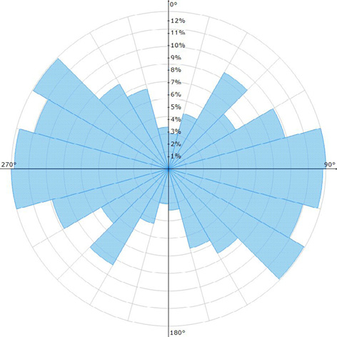
Fig. 9. Rosette diagram showing the directions of the deposition of finds from the 2023 season in Trench II.
9 pav. Rozetės diagrama, kurioje pavaizduotos 2023 m. sezono II tranšėjos radinių nusėdimo kryptys.
The flow layer (layer 8) is extremely interesting in many respects. Its in-depth recognition can answer a number of questions concerning site 24 in Poręba Dzierżna. This layer, present in all identified trenches, covers the mine shafts. In zone 2, distinguished on the basis of LIDAR, it is responsible for the fact that the outlines of the shafts are very poorly legible. Trench II located in this zone before the beginning of excavation work was basically invisible on the surface. For this reason, it cannot be ruled out that the mining field may be larger than indicated by LIDAR. In this layer, as well as in the fill of mine shaft A, there are artifacts with workshop characteristics. Due to their origin from the initial phases of exploitation, as well as their undoubtedly redeposited nature, these materials cannot be unambiguously dated. Based on the results of the spatial analysis, it is difficult to consider them as homogeneous material. For this reason, it is extremely important to find the place of their original deposition. This is only possible in the case of materials from the flow layer 8. Detailed examination of this layer and reaching the original location of the workshop will allow for a more precise dating of flint activity in the mining field (more precise than OSL or C14 dates from displaced sediments), and it will also allow linking production with specific cultural units. The data obtained during detailed studies of the flow layer will also allow for determining the range, chronology and nature of the mass movement that destroyed a significant part of the site. The key question seems to be its genesis (whether it was related to human activity or only to natural slope processes).
The research results presented in this article are only a starting point for further work. Spatial analyses, which have already allowed for expanding knowledge about the site, will be further used, and their scope will be expanded. This has proven that, although the use of such a detailed analysis is not common in prehistoric mine research (due to the number of finds and the size of the sites), it brings very valuable results. In the next seasons, it is planned to use spatial analysis to select sites for further research aimed at determining the location of the flint workshop. These works will be complemented by a series of drillings with a hand drill and survey trenches. The weight of the artifacts, as well as their detailed analysis, will allow for an estimate of the size of flint production in the mining field in the Udorka Valley. The project is scheduled to be completed no later than 2027. The results obtained after a comprehensive analysis will allow for a description of the research procedure used along with the innovations practiced. If the adopted assumptions are confirmed, this method will be able to be employed on many other destroyed and displaced sites down the slope.
Bibliography
Balcer B., 2000. Znaczenie badań ciężaru znalezisk krzemiennych. Borkowski W. (ed.) Metody badań archeologicznych stanowisk produkcyjnych - górnictwo krzemienia, Warszawa, pp. 297-306.
Binnebesel H., 2022A. Zespoły krzemienne z Poręby Dzierżnej (stanowisko 24, woj. małopolskie) z badań archeologicznych w latach 2019–2021 w świetle analizy przestrzennej, unpublished master’s thesis, Diploma Thesis Archive, Nicolaus Copernicus University in Toruń.
Binnebesel H., 2022B. Miejsce pozyskiwania i wstępnej obróbki surowca krzemiennego w pradziejach. Przykład wstępnie rozpoznanego stanowiska górniczego w Porębie Dzierżnej 24, gm. Wolbrom woj. Małopolskie. Andrzejewska A., Olczyk A., Podolska I. (eds.) Życie przedmiotu. Od surowca do eksponatu, Łódź, pp. 29-49.
Ginter B., Kozłowski J. K. 1975. Technika obróbki i typologia wyrobów kamiennych paleolitu i mezolitu, Warszawa.
Lech J. 1981. Górnictwo krzemienia społeczności wczesnorolniczych na wyżynie krakowskiej. Wrocław.
McPherron S. 2005. Artifact orientations and site formation processes from total station proveniences. Journal of Archaeological Science 32 (2005), pp. 1003-1014.
Mizerski W. 2022. Geologia dynamiczna. Warszawa.
Sanchez-Romero L., Benito-Calvo A., De Loecker D., Pope M. 2023. Spatial analysis and site formation processes associated with the Middle Pleistocene hominid teeth from Q1/B waterhole, Boxgrove (West Sussex, UK). Archaeological and Anthropological Sciences 15.
Sudoł-Procyk M., Budziszewski J., Krajcarz M. T., Jakubczak M., Szubski M. 2018. The Chocolate Flint Mines in the Udorka Valley (Częstochowa Upland) – a preliminary Report on the Field and Lidar Surveys. Werra D. H., Woźny M. (eds.) ,Between History and Archaeology, Oxford, pp. 89-102.
Sudoł-Procyk M., Krajcarz M. T., Malak M., Werra D. 2021. Preliminary characterization of the prehistoric mine of chocolate flint in Poręba Dzieżna, site 24 (Wolbrom commune, lesser Poland voivodeship). Włodarczy P. (ed.) Sprawozdania Archeologiczne tom 73 nr 2, Kraków, pp. 109-136.
Sulgostowska Z. 2005. Kontakty społeczności późnopaleolitycznych i mezolitycznych między Odrą, Dźwiną i górnym Dniestrem, Warszawa.
Hubert Binnebesel, Magdalena Sudoł-Procyk
Summary
The mining field is located on a steep slope of a river valley (the Udorka Valley). It covers an area of at least 1 ha. The stratigraphic situation of the site is quite complicated. Beneath the humus, there is a loess layer with redeposition features, which is very rich in artifacts (layer 8). Below it, there is sediment, most likely in situ. There are also artifacts in it, but this layer is heavily damaged. Beneath it, there are layers of compacted in situ loess, clays and weathered limestones devoid of artifacts. The Mining Shafts are covered by a layer of redeposited loess. The process of redeposition and the destruction of the in-situ layer with artifacts were most probably caused by the same phenomenon. It was most probably a mudflow which took place in prehistoric times.
The complicated stratigraphic situation was the starting point for considerations on the homogeneity of the flint finds collection. In order to verify this thesis, spatial analysis of artifacts was performed. As a result of these studies, it was possible to observe 5 different horizons of the formation of the shaft backfill. Each of the distinguished horizons differed in the number and density of finds, but also in their characteristics (types or the presence of burnt specimens). For this reason, the artifacts from the fill cannot be considered homogeneous and should be analyzed as separate collections.
The flint finds from the redeposited layer 8 also do not form a homogeneous assemblage. Differences in the arrangement of artifacts were observed in the upper and lower parts of this sediment. This allows us to assume that this layer was not formed as a result of a single phenomenon. Although the artifacts are of the workshop type, their simultaneity should be doubted. In order to establish the chronological and cultural framework of flint production in the mining field, it seems necessary to determine the original location of the workshops, which were destroyed and washed out as a result of some kind of mudflow.
Work is currently underway to achieve this goal. In this research, more extensive spatial analysis is used, taking into account the azimuths of the individual finds. The initial results of the work indicate that this is a promising direction.
Hubert Binnebesel, Magdalena Sudoł-Procyk
Santrauka
Nuo 2018 m. Udorkos slėnyje esančioje priešistorinėje šokoladinio titnago kasykloje (24 vietovė, Poręba Dzierżna, Mažosios Lenkijos vaivadija, Pietų Lenkija) atliekami kasinėjimai. Tai pirmoji šios žaliavos kasykla, aptikta už Świętokrzyskie kalnų ribų. Ši žaliava vaidino svarbų vaidmenį Vidurio Europos priešistorinių bendruomenių ekonomikoje. Šiuo metu turimas datavimas rodo, kad kasykla buvo naudojama mezolito ir neolito laikotarpiais.
Titnago kasykla yra stačiame upės slėnio (Udorkos slėnio) šlaite ir užima ne mažesnį kaip 1 ha plotą. Vietovės stratigrafinė padėtis gana sudėtinga. Po humuso sluoksniu yra priesmėlio sluoksnis, kuriame labai gausu artefaktų (8 sluoksnis). Tik žemiau po juo yra nuosėdų, greičiausiai in situ. Jame taip pat yra artefaktų, tačiau šis sluoksnis labai pažeistas. Po juo in situ yra priemolio, molio ir suirusių kalkakmenių sluoksniai be artefaktų. Kasyklos šachtos taip pat padengtos priesmėlio sluoksniu. Šį procesą ir in situ sluoksnio su radiniais sunaikinimą greičiausiai lėmė tas pats reiškinys. Greičiausiai tai buvo priešistorėje vykęs purvo tekėjimas.
Sudėtinga stratigrafinė situacija buvo atspirties taškas svarstymams apie titnago radinių kolekcijos homogeniškumą. Siekiant patikrinti šią hipotezę, buvo atlikta artefaktų erdvinė analizė. Atlikus analizę, pavyko pastebėti 5 skirtingus šachtos užpildo formavimosi horizontus. Kiekvienas iš išskirtų horizontų skyrėsi ne tik radinių skaičiumi ir tankumu, bet ir jų savybėmis (radinių tipais ar degimo požymiais). Dėl šios priežasties užpildo radiniai negali būti laikomi homogeniškais ir turėtų būti analizuojami kaip atskiros kolekcijos.
Titnaginiai radiniai iš judinto 8 sluoksnio taip pat nesudaro vienalytės kolekcijos. Šių nuosėdų sluoksnio viršutinėje ir apatinėje dalyse pastebėta radinių išsidėstymo skirtumų. Tai leidžia daryti prielaidą, kad šis sluoksnis susiformavo ne kaip vieno reiškinio rezultatas. Nors artefaktai yra dirbtuvių tipo, jų vienalaikiškumu reikėtų abejoti. Norint nustatyti chronologines ir kultūrines šios titnago kasimo ir apdirbimo vietos ribas, atrodo, būtina nustatyti pirminę dirbtuvių vietą, kuri buvo sunaikinta ir išplauta dumblo srovės.
Šiuo metu vykdomi darbai šiam tikslui pasiekti. Šiame tyrime taikoma platesnė erdvinė analizė, atsižvelgiant į atskirų radinių azimutus. Pirmieji darbo rezultatai rodo, kad tai perspektyvi kryptis.